The cliffs to the North of St Abb's Head Nature reserve. You can clearly see the layers of sedimentary rocks which were laid down between 460 and 410 million years ago.
The cliffs to the North of St Abb's Head Nature reserve. You can clearly see the layers of sedimentary rocks which were laid down between 460 and 410 million years ago.
Pilgrim's Way, Lindisfarne. Holy Island has been a place of pilgrimage since St Aidan established his monastery here in 635. The vertical poles mark the safe route from the mainland to Holy Island.
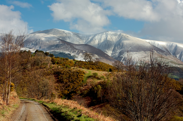
Taken at the bottom of the miner's track leading up to Force Crag, looking back towards the snow covered peaks of Skiddaw. The miners track runs from just outside of Braithwaite to the old, disused Force Crag Mine.
Taken on the way up the miner's track leading up to Force Crag. The black vertical rocks are Force Crag. Just below the crag itself you can just make out the disused mine buildings. The mine was abandoned in 1991 and was the last working mine in the Lake District.
Looking back down the valley. You can see the miner's track leading up to the old, abandoned Force Crag mine. The track runs parallel to Coledale Beck. In the distance is the snow covered Skiddaw.
Looking back down the valley from the top of Force Crag. You can see the miner's track leading up to the old, abandoned Force Crag mine. The track runs parallel to Coledale Beck. In the distance are the snow covered peaks of Skiddaw and Blencathra. The peak to the right of the picture is Stile End.
Taken on the way up the miner's track leading up to Force Crag. The black vertical rocks are Force Crag. Just below the crag itself you can just make out the disused mine buildings. The mine was abandoned in 1991 and was the last working mine in the Lake District.
Looking back down the valley from the top of Force Crag. You can see the miner's track leading up to the old, abandoned Force Crag mine. The track runs parallel to Coledale Beck. In the distance are the snow covered peaks of Skiddaw and Blencathra. The peak to the right of the picture is Stile End.
Castlerigg stone circle sits above the town of Keswick in the English Lake District.
The stone circle dates from approximately 3200 BC. Legend has it that it is impossible to count the number of stones in the circle, you'll allegedly get a different number each time you try. From the circle it is possible to see the peaks of Helvellyn, Skiddaw, Grasmoor and Blencathra, some of the highest in Cumbria.
Rydal Water lies between Grasmere and Ambleside in the Lake District.
This image was taken from the Southern end of Rydal Water, looking North towards Grasmere. The Lake District is one of my favourite places on earth, especially in the spring time with snow on the mountain tops. I'm certainly not alone in this, near to where I took this is Wordsworth's Seat, though to be the poet's favourite view in the Lake District.
Fisherman's hut on Holy Island. The huts are made from upturned old disused fishing boats. The local fishermen believed it to be a sin to scrap old boats so, when the old wooden boats became unnecessary at the end of the 20th century, they were put to good use as storage sheds.
Fisherman's hut on Holy Island. The huts are made from upturned old disused fishing boats. The local fishermen believed it to be a sin to scrap old boats so, when the old wooden boats became unnecessary at the end of the 20th century, they were put to good use as storage sheds.
Fisherman's hut on Holy Island. The huts are made from upturned old disused fishing boats. The local fishermen believed it to be a sin to scrap old boats so, when the old wooden boats became unnecessary at the end of the 20th century, they were put to good use as storage sheds.